 |
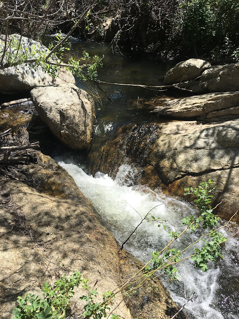
| Lower Green Valley Falls offers a welcome sight in drought-prone San Diego County |
We figured our hike in early May 2017 would be our last hike of the season in the Cuyamacas, but a surprising late season storm the second week of May dropped several inches of rain in the mountains and snow at the higher peaks. So, on Mother's Day, we decided to make a return trip to check out the waterfalls near the Green Valley Campground. On a previous visit in 2016, we had intended to visit the falls, but due to the drought, a park ranger said, "Why bother?" However, this year, we weren't disappointed.
It is a very easy walk from the parking lot to the falls and few people were in the area...so few that we saw no other people for over half of our hike. The falls are along the headwaters of the Sweetwater River and they cascade through a series of very large boulders with deep clear pools between them. There was a lot of running water and this created a scene very different from most of waterless San Diego County.
 |
| Can you find Scott in this photo? |
 |
| Impressive rock formations compete with stunning vistas for hikers' attention |
Green Valley, located towards the southern end of Cuyamaca Rancho State Park at an elevation of 4,000 feet, is lower than Cuyamaca Peak (6,512 feet at the summit). Consequently, there were a number of plants that don't appear at higher elevations. The first of these was a bright yellow mimulus that prefers the wetter soils near water. There were also a few areas with chaparral peas, which look a lot like old-fashioned sweet peas. Several large
Dudleya rosettes clung to the steep sides of cliffs above the trail. In a small open grass area, there were soft pink
Calochortus splendens, or splendid mariposa lily. (I was hoping we would find some of these!) A few large oak trees, which were somehow missed by the fire, shaded one area of the trail and, as with the view looking out toward the east from Cuyamaca Peak seen the week before, I was reminded of what the area had looked like before the 2003 Cedar Fire.
 |
| Mimulus |
 |
| Dudleya |
 |
| Phacelias |
 |
| Wonderful granite rocks on the west side of south peak |
 |
| Yellow sticky monkey flowers, Mimulus, are among the flora that have returned since the Cedar Fire |
 |
| Chinese Houses and Phlox |
 |
| Swallowtail butterfly |
 |
| View of middle and north peak of Cuyamaca Mountain |
 |
| White Phlox |
 |
| Climbing pea |
 |
| Dudleya |
As we continued up the hill and onto the west facing slopes, the plants became more typical of the lower elevation foothills farther north:
Ceanothus, manzanita, various
Salvia, wooly blue-curls,
Hesperoyucca, Chinese houses, white
Phlox, and red
Penstemon. A whole hillside was covered with manzanita that had grown after the fire. Beneath the manzanita grew a seemingly endless groundcover mat of
Salvia sonomensis, more likely to be seen in the Sierra foothills than in San Diego. It was a bit of a surprise to find several of our native peonies (yes, we have a native peony),
Paeonia californica. It usually grows in the shade at the edge of other chaparral plants and, unfortunately, has small dark downward facing flowers. Maybe someday someone will hybridize it with other peonies and we will be able to grow peonies in our Southern California gardens. Also in the area was the sticky monkey flower,
Diplacus (Mimulus) aurantiacus. I remember these growing in the same area decades ago and was glad to see they had returned after the fire.
 |
| Scott under alley of live oaks |
 |
| Penstemon |
 |
| Paintbrush |
 |
| Hesperoyucca whipplei |
 |
| Oakzania Peak |
 |
| Hesperoyucca whipplei seedpods |
 |
| Buckwheat and Wooly Blue Curls |
 |
| White Sage |
 |
| Chamise coming into bloom |
 |
| Resprouting burned oak trunk |
 |
| Sweetwater River lined with deciduous bright green trees |
 |
| Sweetwater River lined with deciduous bright green trees zoomed in |
 |
| More great rock formations |
 |
| Acorns left by woodpeckers |
 |
| Paeonia californica |
 |
| Paeonia californica |
We took Pine Ridge Trail back to the parking lot and there were young pines at almost every switchback along the way. Towards the top, there were some interesting rock formations and some great views of Sweetwater River where we had started our hike several hours earlier. We could see where the river made a sharp turn and the tree cover in the tight valley hid most of the river from view. We decided that someday we'd return again to hike that part of the trail.


Comments
Post a Comment